
Hurricane Floyd
September 1999
Quick Facts
Storm Type | Cat. 3 Hurricane
NC Landfall | Cape Fear
NC Wind Speed | 190 mph
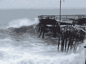
NC Storm Surge | 10 ft
NC Rainfall | 20 in
NC Pressure | 28.05 in
Total Deaths | 57
NC Deaths | 35
Total Cost Then | $6,680,000,000
Total Cost 2009 | $10,045,902,040
about this storm
As hurricane Floyd swept past Florida and turned toward the Carolinas near the peak of the 1999 tropical storm season, there was actually some cause for relief on the part of local officials and storm watchers along the Tar Heel coast. Though the storm clearly was headed their way, most observers were thankful that the once-mighty hurricane was weakening as it edged northward. Just days before it had been a strong category four, and fears of a Hazel- or Hugo-like catastrophe seemed to wane with each update from the National Hurricane Center. Floyd was coming ashore with heavy rains and destructive tides, but at least it was a weaker system — as many viewed it; it would make landfall as only a category two.
What occurred next, of course, resulted in the greatest disaster in North Carolina history. Who could have predicted that such a thing would happen? Who could have foreseen that anything less than a major hurricane would cause such destruction?
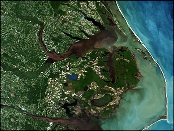
A study of the many storms that have affected the region in the past yields one key observation: though every hurricane is different in size, intensity, and orientation, each has its own unique potential for disaster. Floyd may not have buffeted the state with fearsome winds, but its drenching rains fell on a supersaturated coastal plain and produced record flooding. And like those of hurricane Agnes in 1972 and tropical storm Alberto in 1994, Floyd’s inland floods proved deadly, destructive, and difficult to anticipate. Because most of the prelandfall hype had focused on the incredible winds and potential tides, state and local officials were slow to grasp the time-delayed impact of the disaster.
Barrier island resort towns and other coastal communities have long been sites of emphasis for hurricane preparedness. Their evacuation plans are well scripted, their building standards are high, and their sense of hurricane-readiness is keenly focused. This is only logical, since we have come to expect that most hurricanes will have their greatest impacts on coastal areas near the point of landfall. But more and more, our nation is experiencing hurricanes whose winds and rains cause catastrophic destruction in communities many miles from the coast. Though their effects on beaches should not be downplayed, North Carolina’s three costliest storms — Hugo, Fran, and Floyd — all visited chaos on noncoastal cities like Charlotte, Raleigh, and Greenville. Though inland communities have not traditionally adhered to the same level of preparation as those on the coast, things are changing. After suffering through the floods of Fran and Floyd, dozens of towns far from the ocean are now using their disaster experiences to forge new plans and prepare for future events.
But even if those inland areas had been better prepared for a hurricane, the scope of the Floyd disaster would still have been more than they could handle. The storm’s unprecedented impact caused many to question why the flooding was as bad as it was. Could forecasters not have foreseen the magnitude of the event? Could it happen again? What should we expect when the next great storm hits North Carolina?
Though the National Weather Service knew Floyd would cause flooding if it tracked over eastern North Carolina, no one expected the massive innundation that occurred. Forecast models predicted record flooding for many places with only a projected eight to ten inches of rain, yet the actual rainfall was almost twice that in some areas. Still, the Weather Service did its job by issuing emphatic warnings well in advance of the storm. Steve Harned, director of the National Weather Service office in Raleigh, told the Associated Press: “The rains from Floyd were so far beyond anything we have ever seen that it really couldn’t be forecasted with any degree of accuracy. We don’t use the word `biblical,’ but we probably came as close as we ever will with Floyd. They were the most strongly worded flood watches and warnings we have ever written.”
After the storm, scientists and government officials searched for clues to explain the breadth and severity of the flooding. Though media reports originally described the disaster as a “500-year flood,” officials at the U.S. Geological Survey later said that Floyd was perhaps a 150- or 200-year event. The total amount of rain was substantial, but not as rare as was first believed. Soon others were suggesting that the real cause of the disaster was not “an act of God” but was, instead, the landscape-altering activities of man. As USGS hydrologist Jerad Bales told the Associated Press: “We know it was a big event, but it won’t be as unusual as many first thought it was. All we can do is make statistical estimates. The landscape is changing. There are buildings, bridges, culverts, and lots of development in the watershed. It all has an effect. And so really we don’t know for sure how big or unusual it was.”
In a poststorm editorial in the News and Observer, East Carolina University geologist Stan Riggs described the problem of urbanization in the Piedmont and upper Coastal Plain and how it contributed to the Floyd disaster. He asserted that “we created our own crisis in Eastern North Carolina through systematic and traumatic modification of our watersheds.” Decades of growth have converted forests to farmland and farmland to shopping centers. Years of ditching, paving, bridge building, and stream straightening have altered the natural flow of water across the land. Construction of sewage treatment plants, junkyards, and swine lagoons has been allowed within the 100-year flood plain, creating added risks in times of major flooding. Marginal wetlands were ditched and drained. Roads were built with small culverts that effectively became dams during floods. In all, scientists and planners agree that these land-altering projects were largely to blame for the dramatic flooding seen during Floyd.
Flood maps, which are supposed to delineate areas of risk, were reviewed by a special state task force after hurricane Fran. The group’s 1997 report concluded that, across the state, the existing maps were “inaccurate or grossly out of date.” In the areas hardest hit by Floyd, the study found that 101 communities were using maps that were more than ten years old, some had maps nearly seventeen years old, and 70 towns did not have flood maps at all. Consequently, dozens of cities and counties throughout the east had for years allowed construction in flood-prone areas because of outdated maps. Had the maps been more current, more people would have been covered by flood insurance and the extent of the flooding would have been less surprising.
The cumulative impact of development can cause the floodplain to rise dramatically over a short period of time. When maps for Charlotte and Durham were updated, state officials found that the floodplain had risen an average of four feet above levels indicated on previous maps. Some structures built outside of the flood zone just a few years ago are now at risk of flooding in a 100-year storm. But urbanization is not the only human activity to influence change in the way floods occur. According to the North Carolina Division of Water Resources, land subsidence is another factor that has effectively raised the floodplain and made flooding worse. Subsidence is the sinking of land, in this case caused by decades of unsustainable withdrawals from underground aquifers. The division’s Nat Wilson told the Water Resources Research Institute News: “I can document up to 9 inches of land subsidence in the Central Coastal Plain from 1935 to 1979. If you continue those rates of subsidence, then there has been up to 12 inches of subsidence in this area. A secondary reason for the Floyd flooding is the reduced land surface elevations. A flood event will affect a much larger area because the land has subsided.”
How North Carolina rebuilds after Floyd will have a profound influence on what happens in the next great hurricane. Finding the $20 million required to update flood maps was only one of the challenges lawmakers faced in developing policies to reduce the impact of future storms. Controlling where and how damaged properties are rebuilt was another critical issue. After the storm, Governor Hunt’s administration proposed a new minimum building standard dictating that new homes would have to be built at least two feet above the 100-year floodplain. After pressure by cities, counties, and homebuilders, that proposal was scaled back to a one-foot minimum standard. Though some cities already mandated the one-foot standard, the new rule was designed to guide construction in the dozens of communities where previous restrictions had been few, thereby reducing losses in future floods.
But one of the best plans to minimize future property losses was the continuation of a program begun in the aftermath of hurricane Fran that involved a systematic retreat from low-lying areas along North Carolina’s rivers and streams. Federally sponsored buyouts of at-risk properties in such locations should dramatically reduce damages in future floods. According to the News and Observer: “The buyout aims to be the largest in U.S. history, reclaiming the flood plains from more than 10,000 homes, swine farms, sewage plants, hazardous-waste sites, and drinking water systems. Officials hope forests and wetlands, nature’s best flood control, will take their place.” In the months following Floyd, thousands of homes and business properties across the eastern counties were purchased, later to be relocated or demolished. Eric Tolbert, the state’s emergency management director, described the benefits of the program: “In essence, those are 4,000 families that will not be exposed to the consequences of another flood in eastern North Carolina. Beyond those buyouts, hurricane Floyd has presented a real opportunity to examine decisions made in the past, and to some degree, set a new course for eastern North Carolina.”
But controversy continues to boil over the question of rebuilding communities where the risks are high. Some wonder why taxpayers should have to support the repeated reconstruction of storm-damaged homes and businesses in areas frequented by hurricanes. Nowhere are these questions more insistent than on the coast, where the state’s barrier beaches took the brunt of at least five hurricanes in the late 1990s. State and federal lawmakers are still wrestling with the issue, but most recognize the economic and social complexities involved. State representative David Redwine, a lifelong coastal resident who co-owns an insurance company, offered a realistic perspective on building at the coast in an article run by the Associated Press: “You have to balance private property rights with what’s in the best interest of the public. . . . The bottom line is: As long as insurance is available, as long as the infrastructure is available, people are not going to move back from the ocean. Everyone wants a little piece of paradise.”
Among issues of hurricane vulnerability and public policy, few topics generate as much controversy as that of beach nourishment. For years property owners, environmentalists, geologists, and engineers have quarreled over the merits of spending millions to pump sand onto erosion-prone barrier beaches. Some argue that the beaches are always moving and shifting and that efforts to artificially stabilize them with dredged-up sand are futile. Furthermore, they point out that these multimillion-dollar, tax-supported projects are at risk of being washed away in a few short years by the next round of hurricanes and winter storms. Their philosophy focuses on pulling structures back away from the vulnerable ocean dune line and limiting new construction in areas of severe erosion. Between 1989 and 1995, about 250 buildings in North Carolina were moved back from the advancing ocean and resettled either on the same lot or on other lots. Perhaps the most famous structural retreat came in the second quarter of 1999, when the Cape Hatteras lighthouse was moved approximately 1,500 feet away from the threatening Atlantic.
Others, however, believe that beach nourishment can be cost effective and that it is necessary to protect the state’s considerable economic investment on the coast. Carolina and Wrightsville Beaches are the sites of two of North Carolina’s oldest nourishment projects, funded mostly by the U.S. Army Corps of Engineers since the mid-1960s. Both endeavors were designed for long-term erosion and hurricane protection and feature high-elevation dunes and broad beaches. Though engineers consider Floyd’s storm surge to have been a 75-year event, not a single building behind the fortified dunes of those two beaches was lost in the storm. Nonetheless, other coastal communities have struggled to develop their own sand replenishment projects. In Carteret County, voters in 1999 rejected a $30 million bond referendum that would have financed the nourishment of seventeen miles of strand from Atlantic Beach to Emerald Isle. That project would have been funded by local taxpayers with no federal support. But lingering questions over the fairness of the project’s funding scheme and uncertainty as to its effectiveness killed the proposal.
Though the debate continues, at least one prominent researcher sees value in the use of nourishment projects on some beaches. Spencer Rogers, a coastal engineer with North Carolina Sea Grant, has studied the effects of recent hurricanes on coastal areas that have been the recipients of sand nourishment and concludes that such projects can be very effective. “The beach nourishment and dunes proved to do exactly what was intended — protect the communities from hurricane-related erosion. It is a treatment. Erosion won’t go away. Rather, nourishment replaces sand that would be lost to natural causes around the shoreline. To be successful, a long-term commitment for adding sand every two to four years is usually required.”
With memories of Fran and Floyd still fresh in their minds, prudent storm watchers are already planning for the next hurricane. Though it may be unpleasant to speculate on the subject, there is little doubt about it — sooner or later, another disastrous storm will come. Perhaps it will be another category three like Fran, a category four like Hazel, or even a series of weaker storms with drenching rains like Dennis and Floyd. No one knows when or where it will strike, but we do know that eventually it will blast ashore and cause massive destruction — perhaps even greater than that caused by previous storms. There is nothing anyone can do to alter that foreboding reality, but the real question is: Will we be ready?
Obviously, we will rely on forecasters at the National Hurricane Center to warn us when the next big storm turns toward the Carolina coast. Technological advances have given meteorologists better tools with which to analyze storm movements, and forecast accuracy has improved over the last few decades. The computer models used to predict hurricane landfalls have become more sophisticated, and other advances, such as the addition of a Gulf Stream IV jet for high-altitude reconnaissance, should enhance the Hurricane Center’s capabilities. The center already has a well-earned reputation for issuing timely, lifesaving warnings about approaching storms. But for all the meteorological improvements, predicting exactly where and when a hurricane will strike, and how strong it will be when it does, remains an elusive goal. The Hurricane Center’s average error in a twenty-four-hour forecast is currently around 100 nautical miles, down from about 120 nautical miles in 1960. Neil Frank, director of the center from 1974 to 1987, summarized the problem thus: “While I was at the Hurricane Center, there was only a 10 percent improvement in forecast error in twenty-five years. At the same time, the coastal areas were just exploding in population. The increase in population is far surpassing any small improvement we are realizing in our ability to forecast hurricanes.”
Though meteorologists are improving their techniques for determining where hurricanes might go, they still struggle with forecasts of hurricane intensity. Our burgeoning coastal population faces its greatest threat from a rapidly intensifying storm that accelerates toward the shore. This is the scenario that emergency planners fear most and that hurricane meteorologists have the toughest time forecasting. Consequently, forecasters must be cautious, and coastal residents should expect to sometimes suffer through large-scale evacuations for storms that may weaken before they make landfall. Under these conditions, the maxim for life on the coast is truly “better safe than sorry.” Hurricane Center director Max Mayfield described his agency’s progress: “I think we will see a continued, gradual improvement in the track forecasts. In my opinion, however, we are several years away from making significant improvements in intensity forecasting. We really want people to know that there is little skill in forecasting rapidly strengthening hurricanes.”
In planning for the next great storm, the citizens of North Carolina have now had the greatest of teachers — firsthand experience. After enduring so many hurricanes in the late 1990s, including major disasters with Fran and Floyd, they can use the lessons learned and the mistakes made to better prepare for the next event. A wealth of experience was gained by emergency management officials, state and local governments, and others who worked through the recovery process. Written plans and procedures may be necessary, but the efforts to coordinate disaster recovery on an unprecedented scale provided countless unwritten learning opportunities. In the wakes of Fran and Floyd, new relationships were forged and cooperation was extended between public and private agencies, governments, businesses, churches, relief organizations, and families. The next time a big hurricane rolls through the state, many mistakes made in previous storms will be corrected, cooperative efforts should be strengthened, and all those involved will have the benefit of past experience.
According to Eric Tolbert, director of the North Carolina Division of Emergency Management, coordination and planning on the state level have improved significantly with each disaster experience: “Perhaps the most pointed improvement is the philosophical change of being proactive versus reactive in response and recovery efforts. Through strategic placement of operational facilities and transportation and commodity contracts, the state is positioned to provide immediate support to impacted communities, while also saving the state money. We now place well-trained teams of state and local officials in county emergency operations facilities, which provide resource support to counties severely impacted. With experience the state’s response was improved, which constituents expect, just as they will expect from hurricane Floyd to the next event. Floyd presented new response challenges: swift-water rescue in eastern North Carolina; heavy humanitarian airlift operations; disaster mortuary operations; and animal rescue. These consequences are now factored into response planning for future disasters, thus improvements are expected — but we’ll face another set of challenges with the next event.”
Though lessons were learned and plans improved after Floyd, emergency managers and hurricane forecasters still fear the worst when the next monster hurricane looms. In the late 1990s, atmospheric scientist and hurricane prognosticator William Gray of Colorado State University gave emergency planners even more to be concerned about. Not only had he accurately forecasted a string of seasons with above-average hurricane activity, but he also made a long-term forecast that was not promising. Gray, along with other hurricane researchers, believes that we may have entered a period of increased storm frequency that could well last for decades. Gray’s research, which includes such factors as rainfall in Africa’s Sahel region and the effects of El Ni?o and La Ni?a on the tropical atmosphere over the Atlantic, has enabled him to produce an annual prediction for Atlantic hurricane frequency since the early 1980s. The evidence now suggests that North Carolina and the rest of the Atlantic basin may experience more frequent hurricanes in the coming years than have been normal in the last few decades. It would certainly seem that a trend has emerged, since the last five years of the 1990s produced more hurricanes in the Atlantic than any other five-year period on record. It is unknown exactly how long this active period may last, but estimates range from fifteen to twenty-five years. In an interview after Floyd, Hurricane Center director Max Mayfield added: “We are obviously in an active period. It would be very foolish to expect hurricanes to miraculously stop coming. The message from the Hurricane Center has been very consistent. Every individual, every family, every business, and every community needs to have a hurricane plan and have it in place now before a hurricane threatens.”
No one can say exactly when North Carolina will be hit by the next great storm. Most people generally accept the risk, just as midwesterners accept tornadoes and Californians live with the threat of earthquakes. Vast improvements have been made in hurricane forecasting, warning, communications, and recovery, but North Carolina still remains vulnerable. The problems faced by the state today are rooted in geography, population, behavior, and economics. Coastal evacuations are still a primary concern, but now we must face additional challenges across the state. And as more people move into the state and the population ages, the complexity of evacuation and recovery efforts will increase. But common sense is the ultimate weapon against the hurricane threat, and well-prepared residents know that while lost property is replaceable, lives lost are lost forever. If a major hurricane threatens, their cars will be packed and their plans in place to escape the approaching storm. They know it’s not a matter of if — sooner or later another big one will come.
— Excerpt from North Carolina’s Hurricane History by Jay Barnes, Fourth Edition
Through the Lens

Media & Publication Accounts
A FEW HeadLINES
"The Legacy of Hurricane Floyd" via Coastal Review Online
"Hurricane Floyd Series: Hurricane Floyd's Lasting Legacy" via Earth Observatory